

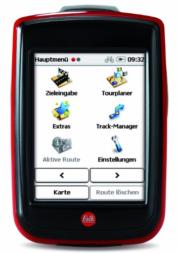
Falk IBEX 25 Europe Touring Bicycle Navigation Device 3.5 Inch Touchscreen Base Map Plus (EU 25) for Touring Cycling, Hiking and Geocaching
Topographic, fully routable base map plus for 25 countries of Europe for cycling, cycling, hiking and geocaching. Premium outdoor maps available for many countries.
Numerous special targets for cyclists pre-installed, including ADFC bed and bike.
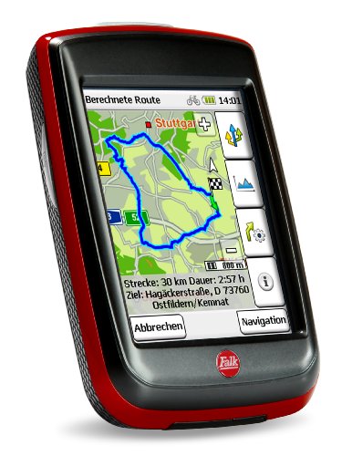
Draw route – plan like your PC: your personalised route is a breeze. With your finger, the route can be easily moved to any point and then automatically adapts to the trail network.
Produktbeschreibung
Falk Outdoor GPS Ibex 25 Europe Touring Tours, Trekking, E-Bike Short trip or connoisseur? With family, friends or alone? Whatever you plan, the IBEX shows you the way – on its extra-large display.
The Falk Ibex Europe Touring is the right navigator for cycling tours of all kinds. Its large 3.5 inch colour display shows the map clearly readable, even in sunlight. Spontaneous day trip? The circular course function makes it possible. And the best part: the Falk IBEX does not need a PC at first, but is ready to use with the base card plus. Base cardPlus: just out and go. Fully routable in up to 25 European countries. An open street map based specially developed by Falk Outdoor. Simply enter the destination address and automatic route guidance starts from the current location. Upgradeable with any Falk Premium Outdoor Map.
Base card plus.
Our Base Card Plus is an OpenCycleMap card specially prepared for our products. It is completely routable including the target location input and thus significantly extends the coverage of your outdoor navigation. For a variety of European countries, we already offer the base cards Plus. Follow more. Of course, you can also depart or plan a route from a premium outdoor map to a base map plus.
Draw Route
Your personalised route is child’s play. With the “Pull Route” function, you can quickly and easily click and pull your favourite tour together. Simply grab the calculated route with your finger and move it to a point you want to pass by. Let go of the route and we adjust the route to the network of paths.
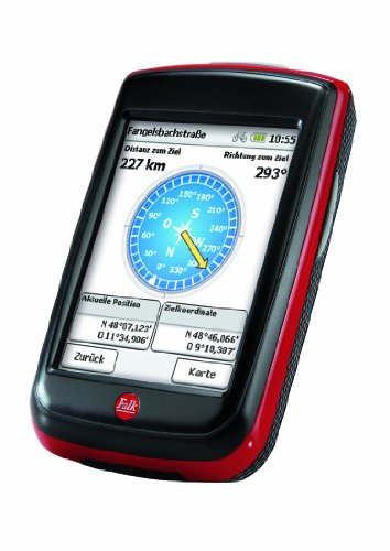
Compass.
With the compass you will find even easier to cache. When you arrive at the cache, our clearly illustrated compass needle helps you where the next cache has hidden. Let yourself be guided by map navigation to the cache and then switch to the compass. So it is even easier for you to lift your treasures.
My route with alternative routes
Individual route options for cyclists or pedestrians, flat and downhill or short – everyone gets their desired route. Transparent with height profile. Even special requests such as strong “avoid slopes” or the display of 3 “alternative routes” can be set.
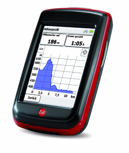
Real-time height profile.
With the real-time height profile, we always show you what comes to you. So you can perfectly divide your powers and know how far it is still to the peak or mountain pass! Even if you turn incorrectly – we show you in real time permanently which height is in front of you.
Mein Rundkurs.
Beautiful weather, 2 hours of time, cycling or hiking shoes are ready – just where to go? Do you want to return to the starting point? Your Falk Outdoor GPS device always suggests the suitable round course including height profile – suitable for your set profile and your planned hike or bike tour! System requirement for synchronising the navigation device with the computer: PC with Windows XP, Windows Vista, Windows 7 or Windows 8 with USB port and internet connection.
Base outdoor POIs.
Our base outdoor POIs provides you with information on more than 1.3 million special destinations in 20 countries in Europe including special outdoor POIs from Kompass and OSM. These range from campsites, bicycle shops and sleepovers, to landmarkets, museum restaurants and many other useful topics.
Rechtliche Hinweise
Neuware vom Fachhändler, Rechnung inkl. MwSt., Versand an Packstation möglich
Topographic, fully routable base map plus for 25 countries of Europe for cycling, cycling, hiking and geocaching. Premium outdoor maps available for many countries.
Numerous special targets for cyclists pre-installed, including ADFC bed and bike.
Draw route – plan like your PC: your personalised route is a breeze. With your finger, the route can be easily moved to any point and then automatically adapts to the trail network.
Paperless geocaching with extra large full screen compass: multi-caches, single caches, … with description texts and hints directly in the navigation – no more printing.
Box contents: outdoor GPS device Falk IBEX 25 Europe Touring, IPX7 (waterproof), bicycle holder, additional cradle as adapter for Herbert Richter/Easy2Fix holder, Li-ion battery 2,000 mAh, USB cable, mains charger, quick start guide.
Specification: Falk IBEX 25 Europe Touring Bicycle Navigation Device 3.5 Inch Touchscreen Base Map Plus (EU 25) for Touring Cycling, Hiking and Geocaching
|
Related Products


